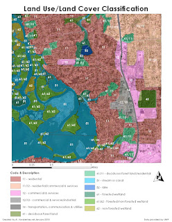
One of the cornerstones of aerial imagery interpretation is arguably the classification of land use and land cover derived from these images. Large swathes of the world can be accurately mapped, with designations for what the land is used for and/or what the land's natural surface is covered with, using methods of aerial imagery classification. These methods mainly rely on the ability of trained interpreters to accurately identify natural and man-made features in a remotely-sensed image.
The above image represents land use and land cover classification from an aerial image, using characteristics like color, texture, pattern, shape and association of the various land types and physical features therein. The squares in the photo, for instance, are obviously buildings, and the green-colored, characteristically shaped/textured areas are obviously trees. The challenge really begins at deciding which buildings are houses, and which are commercial areas, or which trees are deciduous, and which are evergreen. This is where the tools gained from experience and/or training allow the interpreter classifying the image to really identify the specific land uses and covers within the aerial image.

No comments:
Post a Comment